Fort Collins updating the plan for network of paved trails
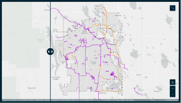
The Strategic Trails Plan will provide a framework for the future planning, design, maintenance and preservation of the city’s recreational paved trail system. Some of these trails, including Spring Creek and the new multi-use trail along Rampart Road (and proposed trails such as those along Overland Trail) connect commuters and visitors to CSU’s Fort Collins campuses.
More information about the planning process is available at ourcity.fcgov.com/stp. View a story map illustrating the history of paved trails in Fort Collins and an interactive map of proposed trails, created by CSU’s own Geospatial Centroid in partnership with the city’s Park Planning and Development Department.
Provide input: Take the online questionnaire open through May 1, and/or drop points on specific trails (both existing and proposed) through an online mapping tool, located on the project page.
Proposed Front Range Passenger Rail would provide connection to CSU System’s three campuses
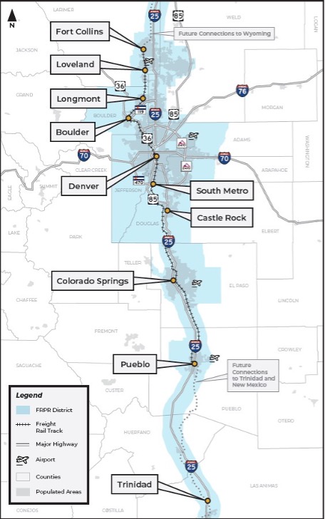
Front Range Rail Commission District is an independent government agency with the mission to plan, design, finance, construct, operate and maintain a new passenger rail system along the Front Range from Fort Collins to Pueblo with eventual connections to Wyoming to the north and Trinidad to the south.
The Commission has selected the route along the Burlington Northern – Sante Fe (BNSF) Rail Line that could potentially connect CSU’s Fort Collins campuses with its Spur and Pueblo campuses. Each community that will host a train station is responsible for developing their own Station Siting Plan that would evaluate and select preferred locations. Fort Collins is expected to begin their planning process within the next year. Representatives from CSU have participated in the technical advisory committee for Northern Colorado communities to represent the CSU students, employees and visitors who could use the line in the future to travel to, from and between the three campus locations.
“Front Range Passenger Rail presents a generational opportunity to connect our three CSU campuses in Fort Collins, Denver and Pueblo while supporting our daily commuters along the Front Range,” said Director of Active Transportation and Fleet Services Aaron Fodge. “Historically, we had a rail connection to Denver from Fort Collins.”
More information is available at Front Range Passenger Rail’s website: ridethefrontrange.com
Provide input: As plans for a commuter rail running along Colorado’s Front Range take shape, the Front Range Passenger Rail District is seeking input from community members who may use the future train for business or recreational trips. Please share how you would use the train from Colorado State University and Fort Collins: form.jotform.com/240306530425041.