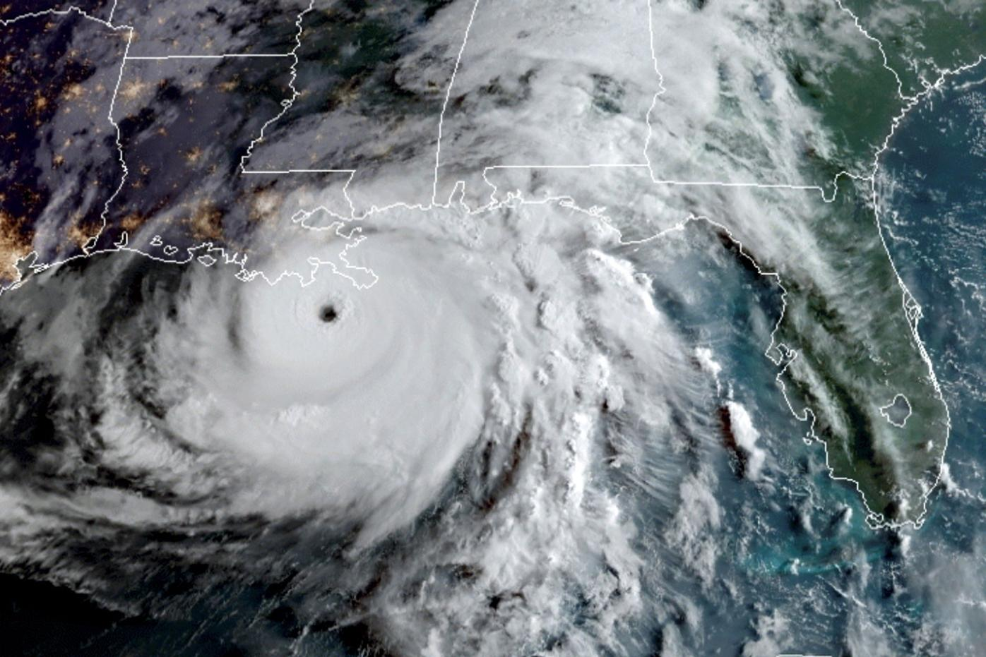
Hurricane Ida on its final approach to landfall in southeastern Louisiana. Courtesy Cooperative Institute for Research in the Atmosphere
When Hurricane Ida made landfall on the Gulf Coast on Sunday, it knocked out power for millions of people — including the entire city of New Orleans. The storm is now one of the most powerful to ever impact the continental U.S.
Colorado State University hurricane researchers have predicted an above-average season for 2021, with the absence of El Nino serving as a major factor.
Alex DesRosiers, a Ph.D. student and member of the CSU Tropical Weather and Climate Research Team, sat down with SOURCE to answer questions about Hurricane Ida and the rest of the 2021 hurricane season.
Source: How does Hurricane Ida compare to previous storms on the Gulf Coast?
DesRosiers: Ida was a notable storm and is best put in context by looking at where it ranks in history among the most powerful hurricanes to impact the continental U.S.
Ida is the seventh strongest in history at the time of its U.S. landfall. The only storm stronger at landfall since the turn of the century was Hurricane Michael in 2018, although it is important to note 2020’s Hurricane Laura was close to packing the same maximum winds at landfall but a less impressive central pressure reading.
When you narrow the question down to Gulf Coast landfalls, Hurricane Andrew (1992) would no longer be included, boosting Ida’s ranking by one spot to sixth strongest.
The Gulf Coast is a clear historical hotspot for our nation’s most devastating hurricanes.
What made Ida unique?
One point of interest the day Ida made landfall was how the storm maintained its strong intensity for many hours despite leaving the ocean. There are two reasons that help explain this, the first being the storm was rapidly intensifying at the time of landfall.
Hurricanes in the process of intensifying take longer to begin weakening when encountering adverse conditions. In contrast, a storm that has been holding its intensity steadily, or is weakening on approach is more likely to decline in intensity quickly when encountering hostile conditions.
The second reason is a phenomenon coined the “Brown Ocean Effect.” The idea is that southeastern Louisiana is composed of swamps, wetlands and saturated soils from heavy repetitive rains this year beginning long before Ida.
This provided an energy source allowing Ida to maintain its structure and intensity further inland. Eventually, the land interaction won out and Ida began to weaken rapidly, but that process was delayed by these factors.
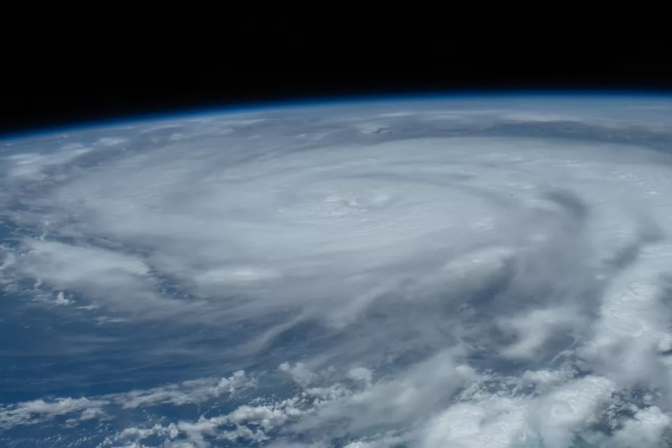
The view from the International Space Station of Hurricane Ida churning in the Gulf of Mexico. Courtesy European Space Agency/Thomas Pesquet
What should people know about when a hurricane turns into a tropical depression?
The most intense moments of the storm may have passed, but it is important to remember that the dangers are not over just because a system is no longer a hurricane or tropical storm. Although the max winds have decreased, there is still the potential for flooding rains and tornadoes. Those in the path of Ida’s remnants should stay aware of the forecast as the inclement weather moves through.
Have you been tracking Ida? What was that process like?
I have been staying up to date with Ida’s forecast, as do other researchers due to the important data collection that goes on. Those forecasts are consistently given by the National Hurricane Center, which is using observations, weather models and their expertise to provide the best guidance for the public.
At the same time, researchers are often meeting and using those same observations and models along with NHC forecasts to identify the best times and places to deploy instruments and capture targeted data that may help shed light on unknowns in the current science.
What are researchers like you watching when a hurricane like Ida makes landfall?
At times like Ida’s landfall, researchers are focused on gathering data to learn from these devastating events and better predict them in the future. Hurricanes that make landfall are often sampled at a much greater rate.
As Ida approached Louisiana, it was sampled by Hurricane Hunter aircraft mounted with a variety of instruments as well as instruments launched from the plane which can profile the atmosphere and gather information about the ocean surface below the storm. An expansive coastal radar network is also actively scanning hurricanes which enter detection range. This is a far greater wealth of information than the purely satellite data often available for storms far out in the remote Atlantic. This data is used to improve our knowledge of hurricanes and in Ida’s case, how they can intensify quickly.
Nighttime visible imagery observations of Hurricane Ida passing through the Gulf of Mexico and making landfall in Louisiana. Seen by the S-NPP VIIRS Near-Constant Contrast (NCC) product (29-30 August 2021). pic.twitter.com/UNmINbQHyD
— CIRA (@CIRA_CSU) August 30, 2021
What happened to the storm when it reached the East Coast and caused the flooding we saw on Sept. 1 in New York and New Jersey?
As remnants of tropical cyclones like Ida approach the mid-latitudes, they can undergo a process called extratropical transition. This allows the cyclone to change from its original state as a warm-core low, which draws its energy from latent heat released during the phase change of water which is no longer a viable energy source to power the storm over land.
Ida became a cold-core low capable of drawing energy from temperature gradients in the surrounding atmosphere rather than the ocean surface. This allowed the cyclone that was once weakening to strengthen again via a new avenue. Ida should finally exit the US on Thursday and continue its trek poleward toward dissipation, but unfortunately after causing a significant flooding event for the northeastern US. This is why it is important to stay aware of the forecast for the duration of a major weather event like Ida if you are in the path of the storm. The threat is not over just because the system no longer has tropical storm or hurricane status.
How did the path/severity of this hurricane match up to the forecasts?
A piece of good news in the wake of tragedy was the stellar and consistent forecasts the NHC gave for Hurricane Ida. Ida underwent a process called rapid intensification, which is an area of ongoing research as it is challenging to predict.
RI is when the maximum winds of a storm increase by 35 mph in a 24-hour period. Ida nearly doubled this rate in the day leading up to landfall. The first advisory for the tropical depression that became Ida explicitly predicted rapid intensification and tied a record for most aggressive three-day intensity forecast issued by NHC for a depression.
Confidence in the forecast was very high for a rapidly intensifying powerful hurricane bringing impacts to southeast Louisiana and remained that way through landfall.
This successful forecasting effort likely saved many lives in the path of the storm where ample warning time was given to citizens and emergency managers alike.
What’s next during this hurricane season? What should people be paying attention to?
Unfortunately, there is plenty of hurricane season left to go. We are not yet at the climatological peak of hurricane activity in the Atlantic.
The CSU seasonal forecast calls for six additional storms, three of these reaching hurricane intensity and one reaching major (category three or higher) hurricane status. This accounts for activity that has already taken place as well as Tropical Storm Larry, which is forecast to be our third major hurricane in the Atlantic by this weekend.
Thankfully this storm is in the far-eastern Atlantic with no land impacts in the forecast for now.
Those who live in hurricane-prone areas should continue to stay up to date with forecasts given by the NHC at nhc.noaa.gov
Tropical Storm Larry has formed in the eastern Atlantic Ocean. pic.twitter.com/gvbsCgpOWD
— CIRA (@CIRA_CSU) September 1, 2021